
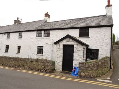
Quaintways, with attached garden wall, Grade II listed building in Vale of Glamorgan. About 150m south of the Town Hall on the road to the beach
Emplacement : Llantwit Major
Altitude : 38,7 m
Coordonnées GPS : 51.40650,-3.48495
Dernière mise à jour : 3 mars 2025 à 14:44

St Illtyd's Church, Llantwit Major
253 m
Llantwit Major Town Hall
183 m
Well opposite Downcross Farm
610 m
Bethel Baptist Chapel
301 m
Tudor Tavern P.H.
203 m
The Old Police Station
260 m
Old White Hart P.H.
239 m
Old Swan Inn
212 m
Llantwit Major War Memorial
228 m
Old Place (or Llantwit Major Castle)
522 m
Court House
359 m
Tabernacle Calvinistic Methodist Chapel
88 m
Cross in Churchyard of Church of St. Illtud
243 m
Downcross Farmhouse including front garden walls
615 m
Plymouth House
399 m
Telephone Call-Box outside Old White Hart P.H.
238 m
West Farmhouse
449 m
Ty-mawr
692 m
Outhouse at Sunny Bank
551 m
Former Chantry Priest's House
237 m
Swimbridge Farmhouse with attached garden walls
422 m
The Gatehouse (porter's Room)
272 m
Corner House
481 m
Footbridge over brook at West entrance to churchyard of Church of St Illtud
279 m
The Old School, including attached walling
300 m
Llantwit Major Dovecote
268 m
Chantry House
230 m
The Old House
493 mAvis
Vous avez visité ce lieu ? Touchez les étoiles pour le noter et partager votre expérience ou vos photos avec la communauté ! Essayez maintenant ! Vous pouvez annuler à tout moment.
Trouvez des trésors cachés à chaque coin de rue !
Des petits cafés pittoresques aux points de vue planqués, fuyez la foule et dénichez les lieux qui vous ressemblent vraiment. Notre app vous facilite la vie : recherche vocale, filtres malins, itinéraires optimisés et bons plans partagés par des voyageurs du monde entier. Téléchargez vite pour vivre l'aventure en version mobile !

Une approche inédite de la découverte touristique❞
— Le Figaro
Tous les lieux qui valent la peine d'être explorés❞
— France Info
Une excursion sur mesure en quelques clics❞
— 20 Minutes