
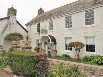
West Farmhouse, Grade II listed building in Vale of Glamorgan. About 200m north and west of the Church of St. Illtud
Emplacement : Llantwit Major
Altitude : 46,2 m
Coordonnées GPS : 51.40967,-3.48895
Dernière mise à jour : 8 avril 2025 à 19:18

St Illtyd's Church, Llantwit Major
205 m
Dimlands
933 m
Llantwit Major Town Hall
274 m
Well opposite Downcross Farm
255 m
Bethel Baptist Chapel
269 m
Tudor Tavern P.H.
251 m
The Old Police Station
256 m
Old White Hart P.H.
213 m
Old Swan Inn
256 m
Llantwit Major War Memorial
227 m
Old Place (or Llantwit Major Castle)
141 m
Cross in Churchyard of Church of St. Illtud
218 m
Court House
264 m
Tabernacle Calvinistic Methodist Chapel
374 m
Downcross Farmhouse including front garden walls
279 m
Plymouth House
76 m
Telephone Call-Box outside Old White Hart P.H.
219 m
Outhouse at Sunny Bank
266 m
Ty-mawr
357 m
Corner House
211 m
Footbridge over brook at West entrance to churchyard of Church of St Illtud
204 m
The Gatehouse (porter's Room)
243 m
Former Chantry Priest's House
231 m
The Old School, including attached walling
151 m
Llantwit Major Dovecote
298 m
Chantry House
254 m
Quaintways, with attached garden wall
449 m
The Old House
238 mAvis
Vous avez visité ce lieu ? Touchez les étoiles pour le noter et partager votre expérience ou vos photos avec la communauté ! Essayez maintenant ! Vous pouvez annuler à tout moment.
Trouvez des trésors cachés à chaque coin de rue !
Des petits cafés pittoresques aux points de vue planqués, fuyez la foule et dénichez les lieux qui vous ressemblent vraiment. Notre app vous facilite la vie : recherche vocale, filtres malins, itinéraires optimisés et bons plans partagés par des voyageurs du monde entier. Téléchargez vite pour vivre l'aventure en version mobile !

Une approche inédite de la découverte touristique❞
— Le Figaro
Tous les lieux qui valent la peine d'être explorés❞
— France Info
Une excursion sur mesure en quelques clics❞
— 20 Minutes