
Table tomb about 2.5 metres east of vestry of Church of All Saints
Table tomb about 2.5 metres east of vestry of Church of All Saints, table tomb in Hollingbourne, Kent, UK
Emplacement : Hollingbourne
Coordonnées GPS : 51.26498,0.64095
Dernière mise à jour : 23 novembre 2025 à 20:05
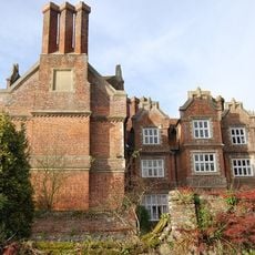
Hollingbourne Manor
215 m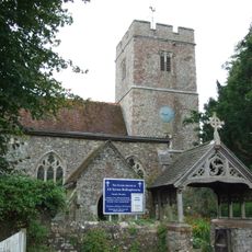
All Saints Church, Hollingbourne
17 m
Bank Cottages
359 m
Woodgate Yew Trees
343 m
The Old Forge
314 m
Wimborne House
987 m
River Farmhouse
973 m
Godfrey House
653 m
64 And 66, Eyhorne Street
976 m
The Old Vicarage
97 m
Grove House
138 m
Six Bells Cottage
64 m
Manor Farmhouse
117 m
Garden Wall About 3 Metres East Of South Wing Of Hollingbourne Manor
191 m
Malt House
289 m
The Pilgrims Rest Inn
310 m
Malt Cottage
269 m
Forge Cottages
321 m
The Old Cottage
47 m
Penn Court
239 m
Garden Wall About 3 Metre East Of Base Of North Wing Of Hollingbourne Manor
213 m
Snagbrook
482 m
Mill House
126 m
Hollingbourne War Memorial
411 m
Table tomb about 2 metres north of porch of Church of All Saints
35 m
Table tomb to Richard Thomas about 43 metres south of Church of All Saints
46 m
Table tomb about 6 metres south of Church of All Saints
28 m
Table tomb about 22 metres south of Church of All Saints
26 mAvis
Vous avez visité ce lieu ? Touchez les étoiles pour le noter et partager votre expérience ou vos photos avec la communauté ! Essayez maintenant ! Vous pouvez annuler à tout moment.
Trouvez des trésors cachés à chaque coin de rue !
Des petits cafés pittoresques aux points de vue planqués, fuyez la foule et dénichez les lieux qui vous ressemblent vraiment. Notre app vous facilite la vie : recherche vocale, filtres malins, itinéraires optimisés et bons plans partagés par des voyageurs du monde entier. Téléchargez vite pour vivre l'aventure en version mobile !

Une approche inédite de la découverte touristique❞
— Le Figaro
Tous les lieux qui valent la peine d'être explorés❞
— France Info
Une excursion sur mesure en quelques clics❞
— 20 Minutes