
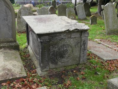
Tombchest of Robert and Martha Ellison, 10 metres southwest of south corner of tower of Church of St Michael
Tombchest of Robert and Martha Ellison, 10 metres southwest of south corner of tower of Church of St Michael, Grade II listed tomb chest in Shotwick, Cheshire, UK
Emplacement : Puddington
Coordonnées GPS : 53.23868,-2.99551
Dernière mise à jour : 10 mars 2025 à 12:48

RAF Sealand
1.8 km
Shotwick Castle
1.8 km
Shotwick House
2.6 km
St Michael's Church, Shotwick
30 m
Shotwick Hall
303 m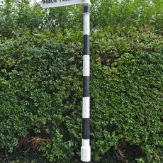
Footpath Guidepost At Junction With Parkgate Road
2.5 km
Gates, gatepiers and churchyard wall along north side of Shotwick Lane
26 m
Front garden walls and gatepiers at Shotwick Hall
292 m
Manor Farmhouse
137 m
L-shaped ranges of farm buildings 60 metres north of Shotwick Hall
371 m
Tombchest of John Nevett Bennett, 5 metres west of south porch of St Michael's Church
16 m
Greyhound Farmhouse
124 m
Footpath Guidepost At Junction Of Pipers Lane Opposite The White House
1.9 km
Sundial in the churchyard of St Michael
17 m
Tombchest of James Phillips, 2 metres south of the sundial in the Churchyard of St Michael
18 m
Granary 30 metres east of Shotwicklodge Farmhouse
1.5 km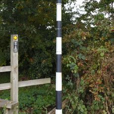
Footpath guidepost 50m east of Heath farmhouse
2.7 km
Former kitchen or bakehouse attached to north east corner of Shotwick Hall
322 m
Tombchest of Rev M Reay and 4 children, 8 metres south of south porch of Church of St Michael
15 m
Tombchest of William Briscoe (died 1723) and others, 4 metres west of priest's door to St Michael's Church
26 m
North Pair of Aircraft Hangars
1.5 km
Barn 70 metres north east of Shotwicklodge Farmhouse
1.5 km
Tombchest of William Briscoe (died 1704) and others, 5 metres southwest of priest's door to St Michael's Church
26 m
Footpath Guidepost 5 Metres North Of Top Lodge
1.7 km
Vicarage Farmhouse
86 m
South Pair of Aircraft Hangars
1.6 km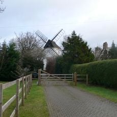
Gibbet Windmill
2.7 km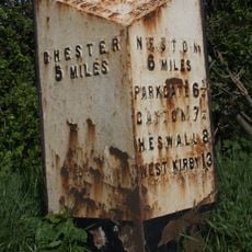
Milepost, Parkgate Road, Woodbank
2.4 kmAvis
Vous avez visité ce lieu ? Touchez les étoiles pour le noter et partager votre expérience ou vos photos avec la communauté ! Essayez maintenant ! Vous pouvez annuler à tout moment.
Trouvez des trésors cachés à chaque coin de rue !
Des petits cafés pittoresques aux points de vue planqués, fuyez la foule et dénichez les lieux qui vous ressemblent vraiment. Notre app vous facilite la vie : recherche vocale, filtres malins, itinéraires optimisés et bons plans partagés par des voyageurs du monde entier. Téléchargez vite pour vivre l'aventure en version mobile !

Une approche inédite de la découverte touristique❞
— Le Figaro
Tous les lieux qui valent la peine d'être explorés❞
— France Info
Une excursion sur mesure en quelques clics❞
— 20 Minutes