Shotwick Castle

Connexion

AroundUs est une carte collaborative des lieux intéressants, construite par des explorateurs curieux comme vous. Elle s’enrichit de chaque avis, anecdote ou photo partagée.
Connectez-vous pour enregistrer vos lieux favoris, contribuer à la carte et créer des itinéraires personnalisés.
En continuant, vous acceptez nos Conditions générales et notre Politique de confidentialité
Ajouter à la collection
Carte
Suggérer une modification
Partager

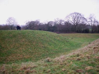
Shotwick Castle, Château médiéval à motte et bailey à Shotwick Park, Grande-Bretagne.

Le château se dresse sur un escarpement avec une motte hexagonale mesurant 40 mètres sur 20 mètres à son sommet au-dessus de la rivière Dee.

Hugh Lupus, Comte de Chester, a construit la fortification en 1093 pour protéger la région frontalière jusqu'à la paix avec le Pays de Galles en 1281.

La transformation de forteresse militaire en parc de chasse royal en 1327 reflète les changements dans la dynamique sociale de la noblesse médiévale anglaise.

Le statut de monument classé protège les vestiges archéologiques, incluant les fondations d'un donjon en pierre enterré à 2.3 mètres.

Deux cours d'eau escarpés bordent les côtés nord et sud du château, tandis que son fossé environnant s'inondait pendant les marées hautes.

Emplacement : Shotwick Park

Emplacement : Saughall and Shotwick Park

Création : 1093

Coordonnées GPS : 53.22720,-2.97608

Dernière mise à jour : 15 mars 2025 à 11:52

Autour de cet endroit
Afficher la carte complète
RAF Sealand
Royaume-Uni

RAF Sealand

1.6 km
Shotwick House
Royaume-Uni

Shotwick House

883 m
St Michael's Church, Shotwick
Royaume-Uni

St Michael's Church, Shotwick

1.8 km
Shotwick Hall
Royaume-Uni

Shotwick Hall

2 km
All Saints Church, Great Saughall
Royaume-Uni

All Saints Church, Great Saughall

1.4 km
St Bartholomew's Church, Sealand
Royaume-Uni

St Bartholomew's Church, Sealand

1.6 km
Churchyard boundary wall, Church of St Bartholomew
Royaume-Uni

Churchyard boundary wall, Church of St Bartholomew

1.7 km
The Old Swinging Gate Inn
Royaume-Uni

The Old Swinging Gate Inn

1.2 km
Bridge Farmhouse
Royaume-Uni

Bridge Farmhouse

1.1 km
Gates, gatepiers and churchyard wall along north side of Shotwick Lane
Royaume-Uni

Gates, gatepiers and churchyard wall along north side of Shotwick Lane

1.8 km
Front garden walls and gatepiers at Shotwick Hall
Royaume-Uni

Front garden walls and gatepiers at Shotwick Hall

2 km
Tombchest of Robert and Martha Ellison, 10 metres southwest of south corner of tower of Church of St Michael
Royaume-Uni

Tombchest of Robert and Martha Ellison, 10 metres southwest of south corner of tower of Church of St Michael

1.8 km
Manor Farmhouse
Royaume-Uni

Manor Farmhouse

1.8 km
Tombchest of John Nevett Bennett, 5 metres west of south porch of St Michael's Church
Royaume-Uni

Tombchest of John Nevett Bennett, 5 metres west of south porch of St Michael's Church

1.8 km
Former kitchen or bakehouse attached to north east corner of Shotwick Hall
Royaume-Uni

Former kitchen or bakehouse attached to north east corner of Shotwick Hall

2 km
Sundial in the churchyard of St Michael
Royaume-Uni

Sundial in the churchyard of St Michael

1.8 km
Greyhound Farmhouse
Royaume-Uni

Greyhound Farmhouse

1.8 km
Tombchest of James Phillips, 2 metres south of the sundial in the Churchyard of St Michael
Royaume-Uni

Tombchest of James Phillips, 2 metres south of the sundial in the Churchyard of St Michael

1.8 km
Granary 30 metres east of Shotwicklodge Farmhouse
Royaume-Uni

Granary 30 metres east of Shotwicklodge Farmhouse

941 m
L-shaped ranges of farm buildings 60 metres north of Shotwick Hall
Royaume-Uni

L-shaped ranges of farm buildings 60 metres north of Shotwick Hall

2 km
Tombchest of Rev M Reay and 4 children, 8 metres south of south porch of Church of St Michael
Royaume-Uni

Tombchest of Rev M Reay and 4 children, 8 metres south of south porch of Church of St Michael

1.8 km
Aldersey House
Royaume-Uni

Aldersey House

1.2 km
Tombchest of William Briscoe (died 1723) and others, 4 metres west of priest's door to St Michael's Church
Royaume-Uni

Tombchest of William Briscoe (died 1723) and others, 4 metres west of priest's door to St Michael's Church

1.8 km
Vicarage Farmhouse
Royaume-Uni

Vicarage Farmhouse

1.8 km
North Pair of Aircraft Hangars
Royaume-Uni

North Pair of Aircraft Hangars

1.5 km
Tombchest of William Briscoe (died 1704) and others, 5 metres southwest of priest's door to St Michael's Church
Royaume-Uni

Tombchest of William Briscoe (died 1704) and others, 5 metres southwest of priest's door to St Michael's Church

1.8 km
South Pair of Aircraft Hangars
Royaume-Uni

South Pair of Aircraft Hangars

1.6 km
Footpath guidepost 25 metres south west of Bridge Farmhouse
Royaume-Uni

Footpath guidepost 25 metres south west of Bridge Farmhouse

1.2 km
Afficher la carte complète

Avis

Vous avez visité ce lieu ? Touchez les étoiles pour le noter et partager votre expérience ou vos photos avec la communauté ! Essayez maintenant ! Vous pouvez annuler à tout moment.

« Shotwick Castle, Château médiéval à motte et bailey à Shotwick Park, Grande-Bretagne » est fourni par Around Us (fr.aroundus.com). Les images et les textes sont dérivés du projet Wikimedia sous licence Creative Commons. Vous avez le droit de copier, distribuer et modifier des copies de cette page, dans les conditions définies par la licence, tant que ce message est clairement visible.

Trouvez des trésors cachés à chaque coin de rue !

Des petits cafés pittoresques aux points de vue planqués, fuyez la foule et dénichez les lieux qui vous ressemblent vraiment. Notre app vous facilite la vie : recherche vocale, filtres malins, itinéraires optimisés et bons plans partagés par des voyageurs du monde entier. Téléchargez vite pour vivre l'aventure en version mobile !

Around Us App Screenshot

Une approche inédite de la découverte touristique

Le Figaro

Tous les lieux qui valent la peine d'être explorés

France Info

Une excursion sur mesure en quelques clics

20 Minutes