
Range To East Of Hunstanworth Farm East Byre Range
Range To East Of Hunstanworth Farm East Byre Range, architectural structure in Hunstanworth, County Durham, UK
Emplacement : Hunstanworth
Coordonnées GPS : 54.83660,-2.07834
Dernière mise à jour : 19 novembre 2025 à 03:42
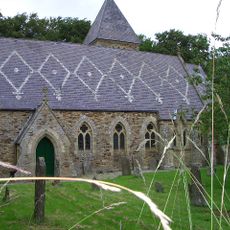
Church of St James
173 m
Townfield Cottages
767 m
South View Cottage The Cottage
140 m
Corner Cottage Mansion Cottage
110 m
Outbuilding North Of Townfield House
679 m
Giant's Stride, West Of The Old School, In Former Schoolyard
710 m
Walls On North Side Of Village Street In Front Of South View, Woodside Cottage, The Cottage, Mansion Cottage, Corner Cottage And The Vicarage, With Gate Piers And Gates
108 m
Hunstanworth Farmhouse
65 m
Hunstanworth Farm West Range
64 m
Stable Block Of Former Vicarage
166 m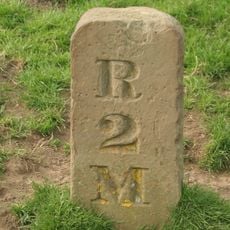
Milestone, Newbiggin, N bank of Beldon Burn, Blanchland Moor
1.1 km
The Old School
704 m
Courtyard And Orchard Walls In Front Of Stable Block
170 m
Walls Enclosing Garden And Yard Of Townfield House
678 m
Tower house in the churchyard of St James's Church
199 m
Hunstanworth Farm East Byre Range
33 m
Moor View (House Opposite Church, Shown As Os Map As Shangri La)
219 m
Walls, Piers And Gates Enclosing Yard Of Church Of St James
209 m
School House
718 m
High Garden House
644 m
Former School And House Attached (Old Church House)
155 m
Hunstanworth Farm North Range
54 m
Townfield House
693 m
Walls Around Former Schoolyard, And Letter Box
743 m
Walls In Front Of Townfield Cottages
754 m
West End, Pine Cottage And Ivy Cottage, With Area Wall And Gates
264 m
Former Vicarage With Terrace Retaining Wall And Steps
148 m
Walls And Gate In Front Of Hunstanworth Farma Nd Farmhouse
79 mAvis
Vous avez visité ce lieu ? Touchez les étoiles pour le noter et partager votre expérience ou vos photos avec la communauté ! Essayez maintenant ! Vous pouvez annuler à tout moment.
Trouvez des trésors cachés à chaque coin de rue !
Des petits cafés pittoresques aux points de vue planqués, fuyez la foule et dénichez les lieux qui vous ressemblent vraiment. Notre app vous facilite la vie : recherche vocale, filtres malins, itinéraires optimisés et bons plans partagés par des voyageurs du monde entier. Téléchargez vite pour vivre l'aventure en version mobile !

Une approche inédite de la découverte touristique❞
— Le Figaro
Tous les lieux qui valent la peine d'être explorés❞
— France Info
Une excursion sur mesure en quelques clics❞
— 20 Minutes