
Sir Richard's Presbytery, architectural structure in Slindon, Arun, West Sussex, UK
Emplacement : Slindon
Coordonnées GPS : 50.86788,-0.63563
Dernière mise à jour : 20 novembre 2025 à 20:03
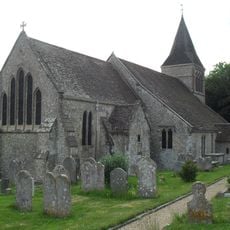
The Parish Church of St Mary
142 m
2, Church Hill
57 m
16 and 17, Church Hill
210 m
9 and 10, Church Hill
87 m
Church House
166 m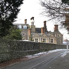
Slindon House
102 m
18, Dyer's Lane
208 m
19, Dyer's Lane
210 m
The Conservatory At Slindon House To The North West Of The House
135 m
The Lodge Of Slindon House To The North West Of The House
155 m
The Stables Of Church House To The South East Of The House
206 m
Tower In The Grounds Of Slindon House To The North West Of The House And Wall Adjoining This On The North
172 m
The Old Post
111 m
Yew Tree Cottage
125 m
Bailiff's House
196 m
Ember Cottage
226 m
Roman Catholic Church of St Richard
23 m
Slindon War Memorial
155 m
No. 1 Slindon
52 m
7, Church Hill
76 m
5, Top Road
86 m
Lime Tree House
65 m
Dower House
99 m
The Cottage
218 m
The Hermitage
93 m
Old Inn House
107 m
13, 14 and 15, Church Hill
137 m
Mulberry House
242 mAvis
Vous avez visité ce lieu ? Touchez les étoiles pour le noter et partager votre expérience ou vos photos avec la communauté ! Essayez maintenant ! Vous pouvez annuler à tout moment.
Trouvez des trésors cachés à chaque coin de rue !
Des petits cafés pittoresques aux points de vue planqués, fuyez la foule et dénichez les lieux qui vous ressemblent vraiment. Notre app vous facilite la vie : recherche vocale, filtres malins, itinéraires optimisés et bons plans partagés par des voyageurs du monde entier. Téléchargez vite pour vivre l'aventure en version mobile !

Une approche inédite de la découverte touristique❞
— Le Figaro
Tous les lieux qui valent la peine d'être explorés❞
— France Info
Une excursion sur mesure en quelques clics❞
— 20 Minutes