Wall on South West Side, wall in Chevening, Sevenoaks, Kent, UK
Emplacement : Chevening
Coordonnées GPS : 51.28496,0.15192
Dernière mise à jour : 21 novembre 2025 à 01:12
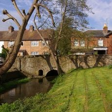
East Side Of Bridge Over River Darenth
188 m
Forecourt Wall To West Of The Rock House
47 m
Old Butcher's Shop
28 m
9-13, High Street
70 m
Hollyhock
31 m
The George And Dragon Public House
117 m
Forecourt Wall To Nos 2 To 16
124 m
Stable Buildings And Cobbled Yard To West Of The Rock House
59 m
Bank House
93 m
Wall To East Of Bank House
151 m
Front Walls And Gateway To North, North East And North West Of West Lodge
199 m
Walls On North East Side
4 m
1-7, Stairfoot Lane
13 m
5, High Street
103 m
15-21, Chevening Road
174 m
Screen Wall To North Of No 3 And Around Corner Along South East Side Of Approach To Mill House
148 m
Crown House
96 m
2-16, High Street
129 m
22-26, High Street
97 m
K6 Telephone Kiosk
31 m
30 And 32, High Street
68 m
Vine Cottage
41 m
The Home Farmhouse
39 m
Chipstead Chapel
48 m
17, High Street
47 m
1 and 3, Chevening Road
149 m
29 And 31, High Street
31 m
The Rock House
69 mAvis
Vous avez visité ce lieu ? Touchez les étoiles pour le noter et partager votre expérience ou vos photos avec la communauté ! Essayez maintenant ! Vous pouvez annuler à tout moment.
Trouvez des trésors cachés à chaque coin de rue !
Des petits cafés pittoresques aux points de vue planqués, fuyez la foule et dénichez les lieux qui vous ressemblent vraiment. Notre app vous facilite la vie : recherche vocale, filtres malins, itinéraires optimisés et bons plans partagés par des voyageurs du monde entier. Téléchargez vite pour vivre l'aventure en version mobile !

Une approche inédite de la découverte touristique❞
— Le Figaro
Tous les lieux qui valent la peine d'être explorés❞
— France Info
Une excursion sur mesure en quelques clics❞
— 20 Minutes