Troy Public High School, high school in Pennsylvania, United States
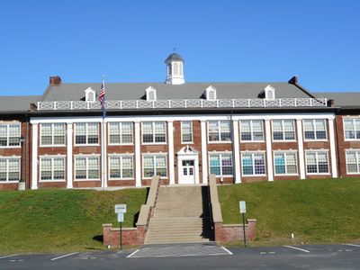
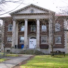
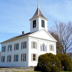
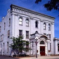
Troy Public High School est un bâtiment scolaire en Pennsylvanie situé sur High Street sur une grande propriété. La structure a été construite entre 1923 et 1924, avec des extensions ajoutées dans les années 1930 et des installations supplémentaires telles qu'un gymnase, une bibliothèque et un auditorium construits en 1954.
Le bâtiment a été reconstruit après un incendie en 1922 et rouvert en 1924 avec des installations modernes. Le lieu a des racines plus profondes, avec une petite école construite en 1823 et une académie établie en 1840 avant la création de la structure actuelle.
L'école porte le nom de Troy et fonctionne comme un point de repère communautaire qui reflète les valeurs locales concernant l'éducation. Sa présence en ville en a fait un lieu de rassemblement pour les résidents de plusieurs générations.
Le bâtiment est situé sur High Street et facile à repérer, avec des panneaux clairs indiquant son statut historique. Gardez à l'esprit qu'il s'agit d'une école active, il est donc préférable d'organiser l'accès à l'avance ou d'observer l'extérieur depuis l'espace public.
Le bâtiment a été conçu par les architectes Lawrie et Lappley et présente une structure en forme de E avec neuf sections verticales. Une coupole octogonale caractéristique couronne le toit, donnant au bâtiment une silhouette reconnaissable sous différents angles.
La communauté des voyageurs curieux
AroundUs rassemble des milliers de lieux sélectionnés, conseils locaux et pépites cachées, enrichis chaque jour par plus de 60,000 contributeurs à travers le monde.