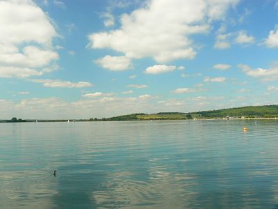
Farmoor Reservoir, lac britannique
Farmoor Reservoir est une grande étendue d'eau dans la Vale of White Horse, gérée par Thames Water et divisée en deux bassins reliés par une digue. Le site comprend un club de voile, des observatoires pour les oiseaux et des réserves naturelles adjacentes comme Pinkhill Reserve avec ses étangs peu profonds et Shrike Meadow, ainsi que des sentiers accessibles autour du périmètre.
Le réservoir a été construit pour stocker l'eau pour la région et est un lieu connu pour l'observation des oiseaux depuis de nombreuses décennies. Shrike Meadow a été ouvert en 2000 et nommé d'après une pie-grièche grise autrefois aperçue là-bas, reflétant la reconnaissance croissante du site comme destination d'observation de la nature.
Le site attire les observateurs d'oiseaux locaux et les amateurs de nature qui se réunissent régulièrement pour observer et enregistrer la faune. Ces activités ont créé une communauté informelle de visiteurs qui partagent leurs observations et contribuent à une longue tradition d'observation attentive de la nature.
Planifiez votre visite en fonction de la saison : l'hiver apporte des canards et des mouettes, l'été offre des sternes reproductices et d'autres oiseaux aquatiques, et les périodes de migration peuvent révéler des espèces inhabituelles. Le site est facilement accessible en voiture avec un stationnement adéquat, des toilettes accessibles et des sentiers plats qui ne nécessitent aucun permis spécial à moins que vous ne souhaitiez entrer dans des observatoires pour les oiseaux.
Le site est connu pour attirer des espèces de mouettes inhabituelles comme les mouettes arctiques pendant ou après des tempêtes, attirant les observateurs d'oiseaux en quête d'observations rares. Ces visiteurs inattendus apparaissent lorsque les perturbations météorologiques poussent les oiseaux loin de leurs habitats habituels, ce qui en fait une destination passionnante pour ceux qui espèrent apercevoir quelque chose d'extraordinaire.
La communauté des voyageurs curieux
AroundUs rassemble des milliers de lieux sélectionnés, conseils locaux et pépites cachées, enrichis chaque jour par plus de 60,000 contributeurs à travers le monde.