Street House, house in West Malling, Tonbridge and Malling, Kent, UK
Emplacement : West Malling
Coordonnées GPS : 51.29286,0.40744
Dernière mise à jour : 26 novembre 2025 à 18:51

Parish Church of St Mary the Virgin
93 m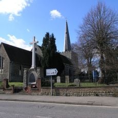
West Malling War Memorial
69 m
106, High Street
81 m
Railings To Old Vicarage
14 m
Lucknow
44 m
Old Vicarage
17 m
Town Pump Situated Opposite Old Vicarage
10 m
129, High Street
20 m
Tudor House
36 m
Church of St Mary Monument To James Godfrey Approximately 30 Metres North Of Chancel
68 m
Railings To Parish Church Of St Mary The Virgin
66 m
104, High Street
90 m
Wall And Gatepiers To Church House
71 m
103 And 105, High Street
93 m
Milverton House
42 m
110, High Street
66 m
Stable To The Vicarage (Vicarage Not Included)
49 m
Forsters
25 m
Tudor Cottage
23 m
Church House
58 m
123, High Street
29 m
Boundary Wall To Brome House
96 m
Church of St Mary Warne Monument 15 Metres North Of West Tower
81 m
115 And 117, High Street
53 m
Wistaria House
58 m
Outbuilding To Rear Of Five Pointed Star Public House
90 m
108, High Street
73 m
107, High Street
86 mAvis
Vous avez visité ce lieu ? Touchez les étoiles pour le noter et partager votre expérience ou vos photos avec la communauté ! Essayez maintenant ! Vous pouvez annuler à tout moment.
Trouvez des trésors cachés à chaque coin de rue !
Des petits cafés pittoresques aux points de vue planqués, fuyez la foule et dénichez les lieux qui vous ressemblent vraiment. Notre app vous facilite la vie : recherche vocale, filtres malins, itinéraires optimisés et bons plans partagés par des voyageurs du monde entier. Téléchargez vite pour vivre l'aventure en version mobile !

Une approche inédite de la découverte touristique❞
— Le Figaro
Tous les lieux qui valent la peine d'être explorés❞
— France Info
Une excursion sur mesure en quelques clics❞
— 20 Minutes