The Limes, architectural structure in East Malling and Larkfield, Tonbridge and Malling, Kent, UK
Emplacement : East Malling and Larkfield
Coordonnées GPS : 51.28481,0.43791
Dernière mise à jour : 23 novembre 2025 à 11:54

Church of St James
349 m
Andrewes Tomb 4 Yards North East Of Malling Church
355 m
4 and 6, Church Walk
316 m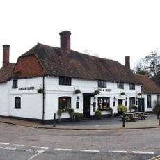
The King And Queen Public House
334 m
Tamarisk Cottage
54 m
Holly Cottage Raven Cottage
62 m
24 And 26, High Street
236 m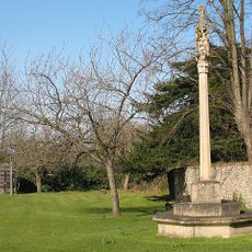
East Malling War Memorial
333 m
Kinross Cottage
75 m
Ivy House Farmhouse
86 m
Rock Farmhouse
334 m
The Forge House
199 m
Court Lodge
354 m
Thornhill Tomb 15 Yards West North West Of East Malling
344 m
Ingleside
301 m
11, Mill Street
313 m
45, High Street
188 m
Paris Farmhouse
367 m
10-16, High Street
272 m
1-5, Mill Street
306 m
Part of an Iron Age enclosure and a minor Roman villa 128m SSE of the Church of St James
285 m
Wall To North East Of The Limes
21 m
6, The Rocks Road
119 m
Barn 30 Yards West Of Ivy House Farmhouse
92 m
Andrewes Tomb 10 Yards North Of East Malling Church
362 m
Andrewes Tomb 6 Yards North Of East Malling Church
358 m
Andrewes Tomb 8 Yards North Of East Malling Church
360 m
The Vicarage
252 mAvis
Vous avez visité ce lieu ? Touchez les étoiles pour le noter et partager votre expérience ou vos photos avec la communauté ! Essayez maintenant ! Vous pouvez annuler à tout moment.
Trouvez des trésors cachés à chaque coin de rue !
Des petits cafés pittoresques aux points de vue planqués, fuyez la foule et dénichez les lieux qui vous ressemblent vraiment. Notre app vous facilite la vie : recherche vocale, filtres malins, itinéraires optimisés et bons plans partagés par des voyageurs du monde entier. Téléchargez vite pour vivre l'aventure en version mobile !

Une approche inédite de la découverte touristique❞
— Le Figaro
Tous les lieux qui valent la peine d'être explorés❞
— France Info
Une excursion sur mesure en quelques clics❞
— 20 Minutes