Mallowes, building in Upwaltham, Chichester, West Sussex, UK
Emplacement : Upwaltham
Coordonnées GPS : 50.91173,-0.66429
Dernière mise à jour : 21 novembre 2025 à 00:41
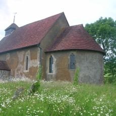
St Mary The Virgin, Upwaltham
616 m
Cross ridge dykes on Sutton Down
1.6 km
Upwaltham Cottage
266 m
Bowl barrow on Glatting Beacon
2.6 km
Bell barrow south-west of Heath Hanger: part of Waltham Down round barrow cemetery
1.4 km
Bowl barrow on Waltham Down, 320 ESE of crossroads: part of Waltham Down round barrow cemetery
1.6 km
One of three bowl barrows on Upwaltham Hill
1 km
Bowl barrow 430m north east of Gumber Farm
2.8 km
Cross dyke 180m north of radio masts at Glatting Beacon
2.6 km
Seven sections of Stane Street Roman road between Eartham and Bignor, a prehistoric linear boundary and two bowl barrows
2.3 km
Double cross dyke on Upwaltham Hill
1.2 km
Barn at Church Farm to the North of the Farmhouse
547 m
Two bowl barrows on Waltham Down, 115m east of crossroads: part of Waltham Down round barrow cemetery
1.7 km
Bowl barrow in Selhurst Park
847 m
Round barrow S of Burton Down
2.3 km
Church Farmhouse
514 m
Droke Farmhouse
1.7 km
Cross dyke on Upwaltham Hill, 500m and 620m south east of Upwaltham Farm
713 m
Denture bowl barrow
2.2 km
Littleton Farmhouse
1.6 km
Bowl barrow on Waltham Down, 200m east of cross roads: part of Waltham Down round barrow cemetery
1.6 km
Two of three bowl barrows on Upwaltham Hill
1.1 km
Bowl barrow on Woolavington Down north-east of Stickingspit Bottom
2.5 km
Bowl barrow on Woolavington Down
2.3 km
Prehistoric linear boundary at Crown Tegleaze, 1km north west of Littleton Farm
1.9 km
Cross dyke on Woolavington Down, 600m south of Lavington House
2.5 km
Cross dyke on Woolavington Down, 625m east of Tegleaze Farm
2.3 km
Selhurstpark Farmhouse And The Cottage Adjoining
2.6 kmAvis
Vous avez visité ce lieu ? Touchez les étoiles pour le noter et partager votre expérience ou vos photos avec la communauté ! Essayez maintenant ! Vous pouvez annuler à tout moment.
Trouvez des trésors cachés à chaque coin de rue !
Des petits cafés pittoresques aux points de vue planqués, fuyez la foule et dénichez les lieux qui vous ressemblent vraiment. Notre app vous facilite la vie : recherche vocale, filtres malins, itinéraires optimisés et bons plans partagés par des voyageurs du monde entier. Téléchargez vite pour vivre l'aventure en version mobile !

Une approche inédite de la découverte touristique❞
— Le Figaro
Tous les lieux qui valent la peine d'être explorés❞
— France Info
Une excursion sur mesure en quelques clics❞
— 20 Minutes