Lower Wear, architectural structure in Bisley-with-Lypiatt, Stroud, Gloucestershire, UK
Emplacement : Bisley-with-Lypiatt
Coordonnées GPS : 51.72898,-2.12866
Dernière mise à jour : 21 novembre 2025 à 08:40

Strawberry Banks
230 m
Three Groves Wood
422 m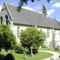
Church of St John the Baptist
1.1 km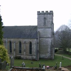
Church of St Bartholomew
69 m
Willow Cottage
863 m
Woodbine Cottage
244 m
Lillyhorn Roman villa, Bournes Green
1.1 km
Soloman's Court With Barn And Shelter Shed
563 m
Hillside Farmhouse
704 m
Stable And Outbuilding To East Of Hillside Farmhouse
690 m
Church View
1.1 km
The Manor House
1.2 km
Avenis Farmhouse
972 m
Laurel Dene
929 m
The Glen
944 m
House Approximately 20 Metres South Of Pipers Cottage
326 m
Penn House
342 m
Manor Farmhouse
848 m
The Court House
819 m
Bakers Mill
562 m
Boundary Wall With 2 Gateways To West Of Church Of St John The Baptist
1.1 km
Little Cottage
347 m
Oakridge War Memorial
313 m
Frampton Place
453 m
The Old Vicarage
136 m
Orchard Cottage And Brook Cottage
781 m
Lyday House And The Sugar House
262 m
Parkfield
894 mAvis
Vous avez visité ce lieu ? Touchez les étoiles pour le noter et partager votre expérience ou vos photos avec la communauté ! Essayez maintenant ! Vous pouvez annuler à tout moment.
Trouvez des trésors cachés à chaque coin de rue !
Des petits cafés pittoresques aux points de vue planqués, fuyez la foule et dénichez les lieux qui vous ressemblent vraiment. Notre app vous facilite la vie : recherche vocale, filtres malins, itinéraires optimisés et bons plans partagés par des voyageurs du monde entier. Téléchargez vite pour vivre l'aventure en version mobile !

Une approche inédite de la découverte touristique❞
— Le Figaro
Tous les lieux qui valent la peine d'être explorés❞
— France Info
Une excursion sur mesure en quelques clics❞
— 20 Minutes