Raspit Hill, building in Ightham, Tonbridge and Malling, Kent, UK
Emplacement : Ightham
Coordonnées GPS : 51.27032,0.26619
Dernière mise à jour : 21 novembre 2025 à 07:41
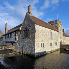
Ightham Mote
1.3 km
The Old House, Ightham Common
1.4 km
Mote Farm Cottages Old Laundry Cottage
1.3 km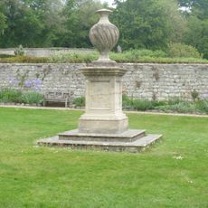
Garden Urn 30 Yards West Of Ightham Mote
1.3 km
Ightham Mote Medieval moated site
1.3 km
Gibbon's Place
1.5 km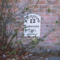
Milestone, Sevenoaks Road, in wall of "Oakenhurst"
916 m
Stone Street Farm Cottage
836 m
Gates, Gatepiers And Mounting Block To South West Of Ightham Mote
1.4 km
The Old House
719 m
Langleys
1.2 km
Holly Tree Cottage
1.4 km
Redwell
1.4 km
Bewley Farmhouse
1.3 km
The Old Cottage The Workhouse
1.1 km
Oast Building At Foxbury Farm
729 m
Pond Farmhouse (Pond Lane)
829 m
Stable Building 20 Yards To East Of Ightham Mote
1.4 km
Mote Farmhouse
1.5 km
East Mote Oast
1.2 km
Ivors
683 m
Harrow Cottage
1.1 km
Yew Tree Cottage
1.3 km
Fir Tree House
697 m
Oasthouse 75 Yards North Of Mote Farmhouse
1.5 km
Lord's Spring Cottage Lord's Spring Cottages
1.3 km
Forge Cottage
697 m
Lavender Plantation
1 kmAvis
Vous avez visité ce lieu ? Touchez les étoiles pour le noter et partager votre expérience ou vos photos avec la communauté ! Essayez maintenant ! Vous pouvez annuler à tout moment.
Trouvez des trésors cachés à chaque coin de rue !
Des petits cafés pittoresques aux points de vue planqués, fuyez la foule et dénichez les lieux qui vous ressemblent vraiment. Notre app vous facilite la vie : recherche vocale, filtres malins, itinéraires optimisés et bons plans partagés par des voyageurs du monde entier. Téléchargez vite pour vivre l'aventure en version mobile !

Une approche inédite de la découverte touristique❞
— Le Figaro
Tous les lieux qui valent la peine d'être explorés❞
— France Info
Une excursion sur mesure en quelques clics❞
— 20 Minutes