
Thornhill Tomb 15 Yards West North West Of East Malling
Thornhill Tomb 15 Yards West North West Of East Malling, building in East Malling and Larkfield, Tonbridge and Malling, Kent, UK
Emplacement : East Malling and Larkfield
Coordonnées GPS : 51.28752,0.44026
Dernière mise à jour : 13 novembre 2025 à 01:05

Church of St James
34 m
4 and 6, Church Walk
64 m
Andrewes Tomb 4 Yards North East Of Malling Church
23 m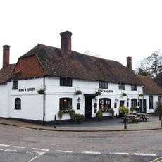
The King And Queen Public House
97 m
Tamarisk Cottage
294 m
Holly Cottage Raven Cottage
282 m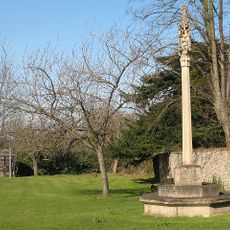
East Malling War Memorial
68 m
24 And 26, High Street
137 m
Kinross Cottage
272 m
45, High Street
156 m
Ingleside
98 m
Paris Farmhouse
454 m
Court Lodge
28 m
11, Mill Street
133 m
The Forge House
158 m
10-16, High Street
113 m
Part of an Iron Age enclosure and a minor Roman villa 128m SSE of the Church of St James
152 m
1-5, Mill Street
103 m
Ivy House Farmhouse
430 m
Wall To North East Of The Limes
327 m
6, The Rocks Road
229 m
69-75, Mill Street
436 m
Barn 30 Yards West Of Ivy House Farmhouse
433 m
Andrewes Tomb 10 Yards North Of East Malling Church
25 m
Andrewes Tomb 6 Yards North Of East Malling Church
24 m
The Limes
344 m
Andrewes Tomb 8 Yards North Of East Malling Church
24 m
The Vicarage
109 mAvis
Vous avez visité ce lieu ? Touchez les étoiles pour le noter et partager votre expérience ou vos photos avec la communauté ! Essayez maintenant ! Vous pouvez annuler à tout moment.
Trouvez des trésors cachés à chaque coin de rue !
Des petits cafés pittoresques aux points de vue planqués, fuyez la foule et dénichez les lieux qui vous ressemblent vraiment. Notre app vous facilite la vie : recherche vocale, filtres malins, itinéraires optimisés et bons plans partagés par des voyageurs du monde entier. Téléchargez vite pour vivre l'aventure en version mobile !

Une approche inédite de la découverte touristique❞
— Le Figaro
Tous les lieux qui valent la peine d'être explorés❞
— France Info
Une excursion sur mesure en quelques clics❞
— 20 Minutes